This website uses cookies so that we can provide you with the best user experience possible. Cookie information is stored in your browser and performs functions such as recognising you when you return to our website and helping our team to understand which sections of the website you find most interesting and useful.

Other Projects
Mohave
Mohave Copper-Molybdenum-Silver Porphyry Project

- Porphyry project with sizable footprint located in the prolific mineral producing Basin and Range Province in Mohave County, Arizona, USA
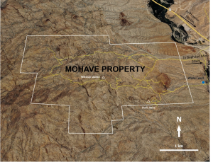
- 16.8 km2 land package, road-accessible and adjacent to Highway 93 which links Las Vegas and Phoenix
- Geologically and structurally analogous to the neighbouring Bagdad mine and typified by structures associated with the Laramide extensional event, like those preferentially mineralized at Bagdad
- 3,500 metres drilled in 2011, extensive ground work by previous operators with some historic mining
Project Summary
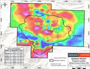
- Magnetics define a sizable ring or donut-type feature characteristic of copper porphyry deposits
- Extensive rock and soil mineralization over a large area of the project with a coincident Induced Polarization (IP) geophysical anomaly (2.5 km x 2.5 km)
- Circular Cu-Mo-Ag soil geochemical and geophysical anomalies are not fully tested by drilling
- Geological, geochemical and geophysical surveys indicate that Mohave is part of an extensive sulphide-bearing hydrothermal system
- Mineralization at Mohave is dominated by potassic alteration having multiple and complex Cu-Mo-Ag events with younger Mo-Ag and Pb-Zn-Ag overprints
- Two small scale historic mines operated on the Mohave property in the 1950’s and 1960’s: the Wikieup Queen copper oxide mine and the Scott Fault molybdenum-lead-silver mine
- Kodiak acknowledges that the Mohave Project is located on the ancestral land of Native Americans
In the late 1960’s and early 1970’s explorers identified Cu-Mo-Ag porphyry mineralization in several shallow churn holes to depths ranging from 30.5 m to 152.4 m. In 2011, eleven wide-spaced core holes totaling 3,500 m were drilled. Highlights of historical drill results at Mohave are shown in Figure 1 and include:
- 59.4 m grading 0.49% Cu
- 65.8 m grading 0.2% Cu, 0.011% Mo, and 2.35 g/mt Ag
- 70.7 m grading 0.3% Cu, 0.01% Mo, and 2.54 g/mt Ag
- A surface trench returned 50.3 m grading 0.24% Cu and 0.076% Mo
Maps & Figures
Photo Gallery
Dave Skelton, P.Geo., Vice President Exploration is the Qualified Person as defined by National Instrument 43-101, and has approved and verified the technical information produced by Kodiak in news releases and on this webpage. Historic data referenced herein is believed to be from reliable sources based on Kodiak’s review of available documentation and select verification work. However, the Company has not independently validated all historic work, and the reader is cautioned about its accuracy.


