This website uses cookies so that we can provide you with the best user experience possible. Cookie information is stored in your browser and performs functions such as recognising you when you return to our website and helping our team to understand which sections of the website you find most interesting and useful.

Projects
MPD
Project Overview
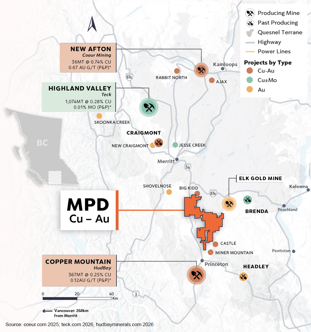
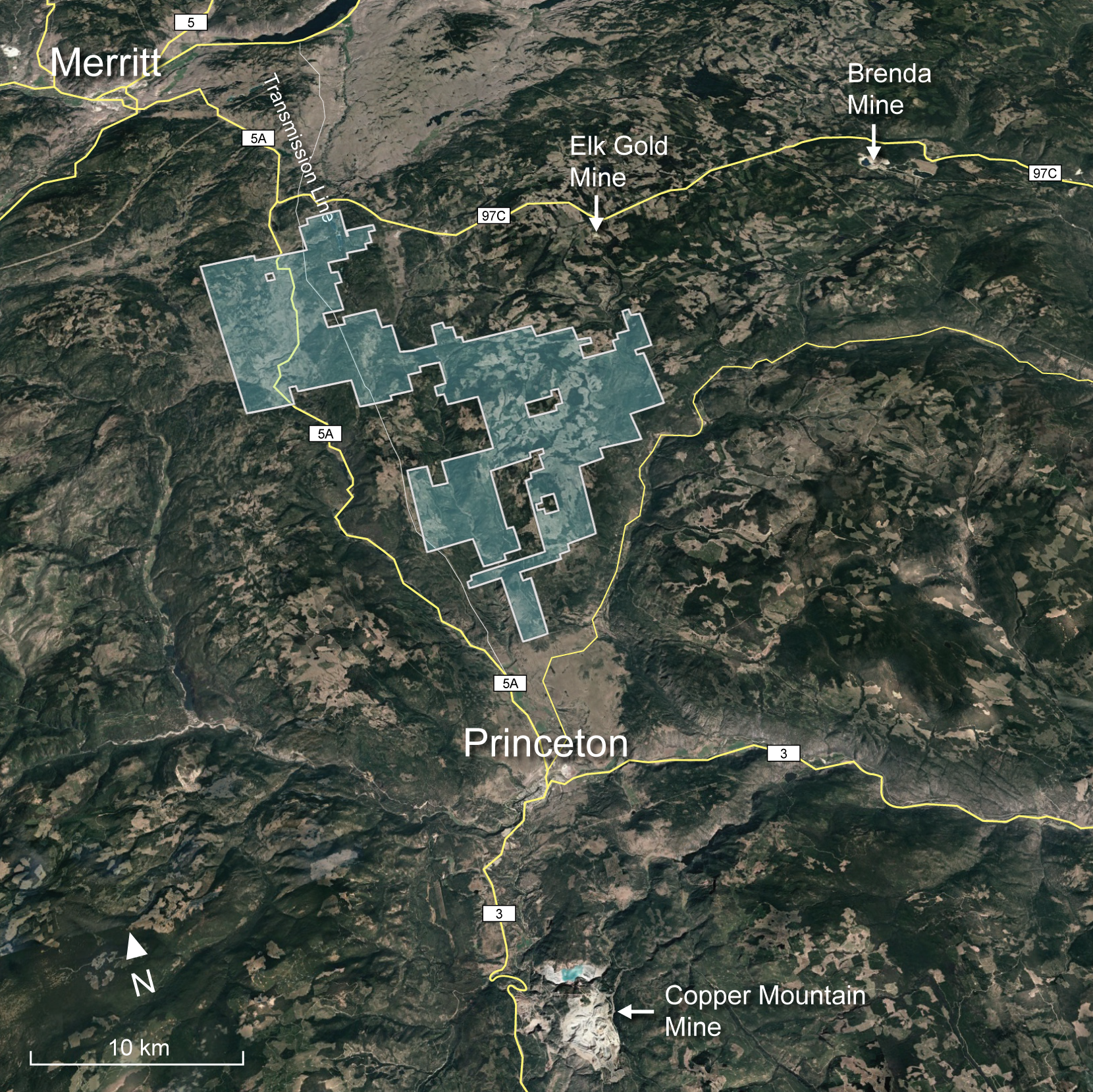
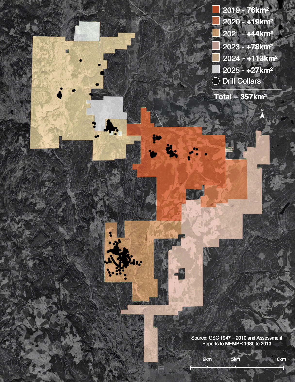
- 100% owned, large land package (357 km2) in South-Central British Columbia, Canada. In an active mining region in the Quesnel terrane, British Columbia’s primary copper-producing belt. Adjacent to paved highways and with excellent infrastructure
- The MPD Project was consolidated from multiple contiguous land packages since 2019, some of which have seen significant historic exploration—forming a large porphyry district that has never before been explored as a single project with modern methods
- Nicola Belt geology with similar characteristics to the neighbouring alkalic porphyry systems at Hudbay’s Copper Mountain Mine to the south and New Gold’s New Afton Mine to the north
MPD Exploration
- Historic drilling: 518 drill holes (73,027m) completed since the 60’s by previous operators. Copper and gold drill-confirmed across a large area. Mineralization from surface, historic drill holes rarely tested below 200m vertical depth
- 192 drill holes (89,122m) completed since 2019 by Kodiak Copper
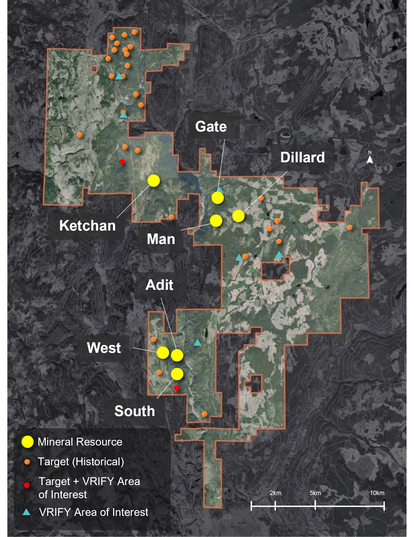
- Discovery of the Gate Zone in Kodiak’s 2019 maiden drill program
- In 2020, transformative discovery of a high-grade copper-gold zone within wider mineralized envelope of significant size at the Gate Zone, highest grades in the 70-year+ history of property
- Best intercept of 535m of 0.49% copper and 0.29 g/t gold, including 282 m of 0.70% copper and 0.49 g/t gold, including 45.7 m of 1.41% copper and 1.46 g/t gold
- Large drill programs in 2021 & 2022 (in total 48,000m) significantly extend the Gate Zone discovery to 1km x 350m, 900m depth and still open. Drilling continued to highlight significant copper-gold grades over substantial intervals
- The 2023, 2024 & 2025 programs drill-tested multiple targets, aiming to build critical mass and demonstrate MPD’s size potential. Results have significantly expanded mineralization at the Adit, West, Man and South Zones
- Kodiak’s exploration programs have shown that MPD hosts multiple kilometre-scale mineralized zones across the property, which include mineralization starting from surface and significant high-grade zones
- The Initial Mineral Resource Estimate published in 2025 outlines seven substantial deposits and underscores the scale and potential of the project. All known deposits remain open to expansion, and numerous targets across the property have yet to be tested
- The 2026 exploration program will focus on growing the Initial Mineral Resource Estimate and will also test several prospective targets with the potential for new discoveries
- Multi-phased environmental work plan includes water quality, hydrology, migratory/nesting bird, species at risk and incidental wildlife surveys. Progressive reclamation of all drill sites
- Active engagement and information sharing with local First Nations. Local sourcing of supplies and services
- Heritage surveys are conducted by local First Nations at all proposed work sites prior to any ground disturbance
- We respectfully acknowledge that the MPD Project is located on the unceded homeland of the Nlaka’pamux and Syilx Okanagan Peoples’
MPD Initial Mineral Resource Estimate

0.20 % CuEq Cut-off Grade
CuEq = Cu(%) + Au(g/t) x 0.6606 + Ag(g/t) x 0.0069.
Based on: Cu Price 4.2 US$/lb, 82% Avg. Recovery. Au Price 2,600 US$/oz, 60% Avg. Recovery. Ag Price 30 US$/oz, 54% Avg. Recovery.
Cut-off grade sensitivity scenarios:
CuEq = Cu(%) + Au(g/t) x 0.6606 + Ag(g/t) x 0.0069.
Based on: Cu Price 4.2 US$/lb, 82% Avg. Recovery. Au Price 2,600 US$/oz, 60% Avg. Recovery. Ag Price 30 US$/oz, 54% Avg. Recovery.
New Release 2025-12-09

Drill Results by Zone
| HOLE ID | FROM (M) | TO (M) | INTERVAL (M) | % CU | AU G/T | AG G/T | AREA | NEWS RELEASE |
|---|---|---|---|---|---|---|---|---|
| MPD-19-002 | 246.0 | 549.0 | 303.0 | 0.13 | 0.09 | 0.81 | Prime | 2020-01-16 |
| includes | 246.0 | 330.0 | 84.0 | 0.11 | 0.19 | 1.09 | Prime | 2020-01-16 |
| and includes | 378.0 | 531.0 | 153.0 | 0.17 | 0.06 | 0.67 | Prime | 2020-01-16 |
| MPD-19-003 | 52.35 | 816.0 | 763.65 | 0.21 | 0.07 | 0.77 | Gate | 2020-01-16 |
| includes | 219.0 | 559.74 | 340.74 | 0.33 | 0.09 | 1.14 | Gate | 2020-01-16 |
| includes | 297.0 | 507.0 | 210.0 | 0.41 | 0.12 | 0.81 | Gate | 2020-01-16 |
| includes | 297.0 | 371.91 | 74.91 | 0.43 | 0.11 | 1.55 | Gate | 2020-01-16 |
| and includes | 404.93 | 507.0 | 102.07 | 0.53 | 0.16 | 1.71 | Gate | 2020-01-16 |
| MPD-20-001 | 152.0 | 778.8 | 626.8 | 0.19 | 0.06 | 0.76 | Gate | 2020-09-03 |
| includes | 340.5 | 616.3 | 275.8 | 0.28 | 0.08 | 1.12 | Gate | 2020-09-03 |
| includes | 340.5 | 483.1 | 142.6 | 0.34 | 0.10 | 1.35 | Gate | 2020-09-03 |
| and includes | 404.7 | 483.1 | 78.5 | 0.39 | 0.12 | 1.71 | Gate | 2020-09-03 |
| MPD-20-002 | 173.0 | 815.0 | 642.0 | 0.21 | 0.06 | 0.84 | Gate | 2020-10-22 |
| includes | 332.0 | 695.0 | 363.0 | 0.26 | 0.06 | 0.98 | Gate | 2020-10-22 |
| includes | 346.0 | 452.0 | 106.0 | 0.32 | 0.09 | 1.30 | Gate | 2020-10-22 |
| includes | 416.2 | 449.0 | 32.8 | 0.46 | 0.12 | 1.50 | Gate | 2020-10-22 |
| and includes | 627.2 | 686.0 | 58.8 | 0.43 | 0.08 | 1.16 | Gate | 2020-10-22 |
| MPD-20-003 | 158.0 | 663.1 | 505.1 | 0.15 | 0.04 | 0.69 | Gate | 2021-02-16 |
| includes | 188.0 | 363.0 | 175.0 | 0.20 | 0.05 | 0.59 | Gate | 2021-02-16 |
| includes | 308.0 | 347.0 | 39.0 | 0.29 | 0.06 | 0.67 | Gate | 2021-02-16 |
| and includes | 399.5 | 608.0 | 208.5 | 0.17 | 0.04 | 0.95 | Gate | 2021-02-16 |
| MPD-20-004 | 201.9 | 737.0 | 535.1 | 0.49 | 0.29 | 1.76 | Gate | 2020-10-22 |
| includes | 201.9 | 263.0 | 61.1 | 0.22 | 0.06 | 0.71 | Gate | 2020-10-22 |
| includes | 263.0 | 545.0 | 282.0 | 0.70 | 0.49 | 2.65 | Gate | 2020-09-03 |
| includes | 305.0 | 530.0 | 225.0 | 0.80 | 0.58 | 2.92 | Gate | 2020-09-03 |
| includes | 329.0 | 482.0 | 153.0 | 0.88 | 0.74 | 3.37 | Gate | 2020-09-03 |
| includes | 329.0 | 425.7 | 96.7 | 1.00 | 0.86 | 4.19 | Gate | 2020-09-03 |
| includes | 380.0 | 425.7 | 45.7 | 1.41 | 1.46 | 5.56 | Gate | 2020-09-03 |
| and includes | 545.0 | 737.0 | 192.0 | 0.27 | 0.06 | 0.80 | Gate | 2020-10-22 |
| MPD-20-005 | 223.5 | 739.3 | 515.8 | 0.41 | 0.22 | 1.50 | Gate | 2020-11-09 |
| includes | 308.0 | 500.0 | 192.0 | 0.74 | 0.48 | 2.75 | Gate | 2020-11-09 |
| includes | 332.0 | 482.0 | 150.0 | 0.84 | 0.57 | 3.06 | Gate | 2020-11-09 |
| includes | 350.0 | 458.0 | 108.0 | 0.94 | 0.68 | 3.28 | Gate | 2020-11-09 |
| and includes | 401.0 | 446.0 | 45.0 | 1.18 | 1.01 | 4.00 | Gate | 2020-11-09 |
| MPD-20-006 | 183.8 | 633.0 | 449.2 | 0.34 | 0.21 | 1.48 | Gate | 2021-02-16 |
| includes | 195.0 | 555.0 | 360.0 | 0.40 | 0.25 | 1.72 | Gate | 2021-02-16 |
| includes | 261.0 | 432.0 | 171.0 | 0.62 | 0.43 | 2.55 | Gate | 2021-02-16 |
| includes | 337.1 | 414.0 | 76.9 | 0.93 | 0.72 | 4.12 | Gate | 2021-02-16 |
| and includes | 376.0 | 414.0 | 38.0 | 1.18 | 1.08 | 5.54 | Gate | 2021-02-16 |
| MPD-20-007 | 279.0 | 720.0 | 441.0 | 0.42 | 0.22 | 1.49 | Gate | 2021-02-16 |
| includes | 435.0 | 648.0 | 213.0 | 0.65 | 0.37 | 2.23 | Gate | 2021-02-16 |
| and includes | 447.0 | 543.4 | 96.4 | 0.75 | 0.42 | 2.52 | Gate | 2021-02-16 |
| MPD-20-008 | Drill Hole Lost | Gate | 2021-02-16 | |||||
| MPD-20-009 | Drill Hole Lost | Gate | 2021-02-16 | |||||
| MPD-20-010 | 212.0 | 749.0 | 537.0 | 0.23 | 0.09 | 1.15 | Gate | 2021-02-16 |
| includes | 212.0 | 315.4 | 103.4 | 0.37 | 0.11 | 2.04 | Gate | 2021-02-16 |
| includes | 269.0 | 315.4 | 46.4 | 0.57 | 0.16 | 1.80 | Gate | 2021-02-16 |
| includes | 522.9 | 661.6 | 138.7 | 0.28 | 0.07 | 0.80 | Gate | 2021-02-16 |
| and includes | 778.0 | 781.0 | 3.0 | 0.05 | 9.62 | 2.40 | Gate | 2021-02-16 |
| MPD-21-001 | 86.0 | 603.5 | 517.5 | 0.10 | 0.02 | 0.35 | Gate | 2021-07-07 |
| includes | 121.9 | 179.0 | 57.1 | 0.12 | 0.03 | 0.31 | Gate | 2021-07-07 |
| includes | 359.0 | 454.9 | 95.9 | 0.17 | 0.03 | 0.50 | Gate | 2021-07-07 |
| and includes | 556.4 | 603.5 | 47.1 | 0.12 | 0.03 | 0.35 | Gate | 2021-07-07 |
| MPD-21-002 | 150.0 | 687.0 | 537.0 | 0.15 | 0.04 | 0.57 | Gate | 2021-07-07 |
| includes | 306.0 | 687.0 | 381.0 | 0.18 | 0.04 | 0.68 | Gate | 2021-07-07 |
| includes | 434.7 | 633.0 | 198.4 | 0.21 | 0.05 | 0.86 | Gate | 2021-07-07 |
| and includes | 453.0 | 603.0 | 150.0 | 0.24 | 0.06 | 0.96 | Gate | 2021-07-07 |
| MPD-21-003 | 102.0 | 648.0 | 546.0 | 0.12 | 0.04 | 0.48 | Gate | 2021-07-07 |
| includes | 444.0 | 648.0 | 204.0 | 0.23 | 0.05 | 0.74 | Gate | 2021-07-07 |
| includes | 498.0 | 648.0 | 150.0 | 0.28 | 0.06 | 0.86 | Gate | 2021-07-07 |
| and includes | 576.0 | 648.0 | 72.0 | 0.39 | 0.09 | 1.23 | Gate | 2021-07-07 |
| MPD-21-004 | 184.8 | 546.2 | 361.4 | 0.35 | 0.18 | 1.50 | Gate | 2021-07-07 |
| includes | 320.0 | 527.0 | 207.0 | 0.47 | 0.27 | 2.06 | Gate | 2021-07-07 |
| includes | 326.0 | 413.0 | 87.0 | 0.58 | 0.32 | 3.33 | Gate | 2021-07-07 |
| and includes | 440.0 | 494.0 | 54.0 | 0.53 | 0.31 | 1.24 | Gate | 2021-07-07 |
| MPD-21-005 | Drill Hole Lost | Gate | 2021-07-07 | |||||
| MPD-21-006 | 143.0 | 821.0 | 678.0 | 0.26 | 0.11 | 0.89 | Gate | 2021-07-07 |
| includes | 323.0 | 686.0 | 363.0 | 0.29 | 0.16 | 1.19 | Gate | 2021-07-07 |
| includes | 436.9 | 515.0 | 78.2 | 0.37 | 0.21 | 1.40 | Gate | 2021-07-07 |
| includes | 623.0 | 674.0 | 51.0 | 0.54 | 0.36 | 2.77 | Gate | 2021-07-07 |
| and includes | 737.0 | 821.0 | 84.0 | 0.40 | 0.08 | 0.50 | Gate | 2021-07-07 |
| MPD-21-007 | 116.0 | 248.0 | 132.0 | 0.15 | 0.08 | 0.43 | Gate | 2021-10-18 |
| MPD-21-008 | 377.0 | 479.0 | 102.0 | 0.15 | 0.11 | 1.10 | Gate | 2021-10-18 |
| MPD-21-009 | 245.0 | 713.0 | 468.0 | 0.25 | 0.16 | 0.51 | Gate | 2021-07-07 |
| includes | 414.0 | 656.0 | 242.0 | 0.38 | 0.22 | 0.63 | Gate | 2021-07-07 |
| includes | 434.0 | 614.0 | 180.0 | 0.43 | 0.27 | 0.67 | Gate | 2021-07-07 |
| and includes | 446.0 | 533.0 | 87.0 | 0.51 | 0.43 | 0.81 | Gate | 2021-07-07 |
| MPD-21-010 | 95.0 | 516.3 | 421.3 | 0.07 | 0.04 | 0.13 | Gate | 2021-10-18 |
| MPD-21-011 | 110.0 | 113.5 | 3.5 | 0.08 | 3.58 | 0.60 | Gate | 2021-10-18 |
| MPD-21-012 | 254.0 | 689.0 | 435.0 | 0.23 | 0.06 | 0.20 | Gate | 2021-10-18 |
| includes | 275.0 | 518.0 | 243.0 | 0.31 | 0.08 | 0.35 | Gate | 2021-10-18 |
| includes | 395.0 | 503.0 | 108.0 | 0.45 | 0.09 | 0.59 | Gate | 2021-10-18 |
| includes | 413.0 | 461.0 | 48.0 | 0.58 | 0.10 | 0.97 | Gate | 2021-10-18 |
| MPD-21-013 | 304.7 | 623.0 | 318.3 | 0.14 | 0.06 | 0.13 | Gate | 2021-10-18 |
| MPD-21-014 | Drill Hole Lost | Gate | 2021-10-18 | |||||
| MPD-21-015 | 182.0 | 297.0 | 115.0 | 0.09 | 0.09 | 0.37 | Gate | 2021-10-18 |
| and | 536.0 | 542.0 | 6.0 | 0.15 | 2.40 | 6.20 | Gate | 2021-10-18 |
| MPD-21-016 | 21.0 | 720.0 | 699.0 | 0.29 | 0.12 | 0.87 | Gate | 2021-10-18 |
| includes | 168.0 | 672.0 | 504.0 | 0.37 | 0.15 | 1.11 | Gate | 2021-10-18 |
| includes | 201.0 | 459.0 | 258.0 | 0.40 | 0.09 | 1.14 | Gate | 2021-10-18 |
| includes | 297.8 | 402.0 | 104.2 | 0.48 | 0.11 | 1.41 | Gate | 2021-10-18 |
| and includes | 567.0 | 672.0 | 105.0 | 0.50 | 0.39 | 1.57 | Gate | 2021-10-18 |
| MPD-21-017 | 158.0 | 455.0 | 297.0 | 0.23 | 0.10 | 0.89 | Gate | 2021-12-14 |
| includes | 257.0 | 338.0 | 81.0 | 0.31 | 0.13 | 1.41 | Gate | 2021-12-14 |
| and includes | 362.0 | 455.0 | 93.0 | 0.31 | 0.08 | 0.73 | Gate | 2021-12-14 |
| MPD-21-018 | 92.0 | 629.0 | 537.0 | 0.37 | 0.11 | 1.40 | Gate | 2021-12-14 |
| includes | 302.0 | 626.0 | 324.0 | 0.51 | 0.14 | 1.85 | Gate | 2021-12-14 |
| includes | 398.0 | 458.0 | 60.0 | 0.56 | 0.16 | 1.88 | Gate | 2021-12-14 |
| and includes | 500.0 | 626.0 | 126.0 | 0.72 | 0.21 | 2.95 | Gate | 2021-12-14 |
| and includes | 704.0 | 791.0 | 87.0 | 0.22 | 0.13 | 1.87 | Gate | 2021-12-14 |
| MPD-21-019 | 27.0 | 249.0 | 222.0 | 0.10 | 0.04 | 0.36 | Gate | 2022-03-08 |
| includes | 177.0 | 213.0 | 36.0 | 0.15 | 0.06 | 0.83 | Gate | 2022-03-08 |
| MPD-21-020 | 33.0 | 159.0 | 126.0 | 0.19 | 0.06 | 0.28 | Gate | 2022-05-04 |
| includes | 36.0 | 129.0 | 93.0 | 0.23 | 0.07 | 0.35 | Gate | 2022-05-04 |
| includes | 60.0 | 120.0 | 60.0 | 0.26 | 0.07 | 0.43 | Gate | 2022-05-04 |
| MPD-21-021 | Drill Hole Lost | Gate | 2021-12-14 | |||||
| MPD-21-022 | Drill Hole Lost | Gate | 2021-12-14 | |||||
| MPD-21-023 | Drill Hole Lost | Gate | 2021-12-14 | |||||
| MPD-21-024 | 302.0 | 749.0 | 447.0 | 0.21 | 0.11 | 0.72 | Gate | 2021-10-18 |
| includes | 311.0 | 425.0 | 114.0 | 0.25 | 0.05 | 0.80 | Gate | 2021-10-18 |
| includes | 512.0 | 554.0 | 42.0 | 0.32 | 0.34 | 1.56 | Gate | 2021-10-18 |
| and includes | 608.0 | 662.0 | 54.0 | 0.30 | 0.18 | 1.22 | Gate | 2021-10-18 |
| MPD-21-025 | Drill Hole Lost | Gate | 2021-12-14 | |||||
| MPD-21-026 | 371.0 | 803.0 | 432.0 | 0.27 | 0.13 | 0.78 | Gate | 2021-12-14 |
| includes | 416.0 | 776.0 | 360.0 | 0.30 | 0.15 | 0.90 | Gate | 2021-12-14 |
| includes | 506.0 | 770.0 | 264.0 | 0.33 | 0.19 | 1.06 | Gate | 2021-12-14 |
| includes | 563.0 | 746.0 | 183.0 | 0.40 | 0.24 | 1.26 | Gate | 2021-12-14 |
| includes | 563.0 | 674.0 | 111.0 | 0.53 | 0.34 | 1.84 | Gate | 2021-12-14 |
| MPD-21-027 | 542.0 | 715.0 | 173.0 | 0.18 | 0.05 | 0.37 | Gate | 2022-03-08 |
| includes | 596.0 | 668.0 | 72.0 | 0.31 | 0.09 | 0.55 | Gate | 2022-03-08 |
| includes | 614.0 | 641.0 | 27.0 | 0.56 | 0.16 | 1.10 | Gate | 2022-03-08 |
| MPD-21-028 | 296.0 | 426.6 | 130.6 | 0.27 | 0.06 | 1.07 | Gate | 2022-03-08 |
| includes | 341.0 | 392.0 | 51.0 | 0.43 | 0.10 | 1.67 | Gate | 2022-03-08 |
| MPD-21-029 | 428.0 | 800.0 | 372.0 | 0.35 | 0.18 | 1.16 | Gate | 2022-03-08 |
| includes | 437.1 | 740.4 | 303.3 | 0.41 | 0.21 | 1.38 | Gate | 2022-03-08 |
| includes | 464.0 | 683.0 | 219.0 | 0.45 | 0.24 | 1.52 | Gate | 2022-03-08 |
| includes | 464.0 | 614.0 | 150.0 | 0.50 | 0.28 | 1.86 | Gate | 2022-03-08 |
| includes | 503.0 | 584.0 | 81.0 | 0.55 | 0.26 | 1.82 | Gate | 2022-03-08 |
| MPD-21-030 | 349.0 | 806.0 | 457.0 | 0.15 | 0.04 | 0.14 | Gate | 2022-05-04 |
| includes | 466.0 | 806.0 | 340.0 | 0.17 | 0.05 | 0.10 | Gate | 2022-05-04 |
| includes | 619.0 | 802.0 | 183.0 | 0.20 | 0.06 | 0.12 | Gate | 2022-05-04 |
| includes | 676.0 | 724.0 | 48.0 | 0.25 | 0.07 | 0.06 | Gate | 2022-05-04 |
| MPD-21-031 | 318.0 | 423.0 | 105.0 | 0.22 | 0.07 | 0.71 | Gate | 2022-03-08 |
| includes | 338.5 | 366.0 | 27.5 | 0.37 | 0.13 | 1.39 | Gate | 2022-03-08 |
| and includes | 402.0 | 423.0 | 21.0 | 0.46 | 0.17 | 1.84 | Gate | 2022-03-08 |
| MPD-21-032 | 414.0 | 594.6 | 180.6 | 0.14 | 0.04 | 0.36 | Gate | 2022-05-04 |
| includes | 507.0 | 594.6 | 87.6 | 0.23 | 0.05 | 0.44 | Gate | 2022-05-04 |
| includes | 531.0 | 561.0 | 30.0 | 0.36 | 0.07 | 0.87 | Gate | 2022-05-04 |
| MPD-21-033 | 464.0 | 536.0 | 72.0 | 0.17 | 0.08 | 1.01 | Gate | 2022-05-04 |
| and | 611.0 | 752.9 | 141.9 | 0.17 | 0.04 | 0.47 | Gate | 2022-05-04 |
| includes | 695.0 | 749.0 | 54.0 | 0.27 | 0.06 | 0.76 | Gate | 2022-05-04 |
| MPD-21-036 | Drill Hole Lost | Gate | 2022-05-04 | |||||
| MPD-22-001 | 324.90 | 335.00 | 10.10 | 0.05 | 0.01 | 0.78 | Gate | 2022-06-29 |
| MPD-22-002 | 401.00 | 628.00 | 227.00 | 0.20 | 0.06 | 0.10 | Gate | 2022-06-29 |
| includes | 581.00 | 628.00 | 47.00 | 0.33 | 0.08 | 0.29 | Gate | 2022-06-29 |
| MPD-22-003 | 611.00 | 712.50 | 101.50 | 0.06 | 0.02 | 0.00 | Gate | 2022-06-29 |
| MPD-22-004 | 308.00 | 809.00 | 501.00 | 0.20 | 0.12 | 0.98 | Gate | 2022-06-29 |
| includes | 452.00 | 566.00 | 114.00 | 0.30 | 0.20 | 2.36 | Gate | 2022-06-29 |
| and includes | 586.70 | 600.50 | 13.80 | 0.40 | 0.38 | 3.90 | Gate | 2022-06-29 |
| includes | 716.00 | 773.00 | 57.00 | 0.33 | 0.16 | 0.15 | Gate | 2022-06-29 |
| MPD-22-005 | 206.00 | 921.20 | 715.20 | 0.13 | 0.07 | 0.65 | Gate | 2022-09-29 |
| includes | 731.00 | 921.20 | 190.20 | 0.19 | 0.12 | 1.07 | Gate | 2022-09-29 |
| MPD-22-006 | 67.70 | 803.00 | 735.40 | 0.24 | 0.14 | 0.71 | Gate | 2022-09-29 |
| includes | 438.70 | 791.00 | 352.30 | 0.40 | 0.24 | 1.12 | Gate | 2022-09-29 |
| includes | 587.00 | 704.00 | 117.00 | 0.69 | 0.46 | 2.22 | Gate | 2022-09-29 |
| includes | 587.00 | 650.10 | 63.10 | 0.82 | 0.56 | 3.13 | Gate | 2022-09-29 |
| MPD-22-007 | Not Assayed | Gate | 2023-06-13 | |||||
| MPD-22-008 | 212.00 | 797.00 | 585.00 | 0.18 | 0.09 | 0.71 | Gate | 2022-09-29 |
| includes | 306.50 | 734.00 | 427.50 | 0.20 | 0.09 | 0.79 | Gate | 2022-09-29 |
| includes | 404.00 | 464.00 | 60.00 | 0.28 | 0.07 | 0.71 | Gate | 2022-09-29 |
| includes | 674.10 | 734.00 | 59.90 | 0.33 | 0.25 | 1.77 | Gate | 2022-09-29 |
| MPD-22-009 | Not Assayed | Gate | 2023-06-13 | |||||
| MPD-22-010 | Not Assayed | Gate/Prime | 2023-06-13 | |||||
| MPD-22-013 | 261.00 | 591.00 | 330.00 | 0.11 | 0.09 | 0.55 | Prime | 2022-09-29 |
| includes | 363.00 | 543.00 | 180.00 | 0.15 | 0.10 | 0.61 | Prime | 2022-09-29 |
| and | 693.00 | 732.00 | 39.00 | 0.11 | 0.20 | 0.70 | Prime | 2022-09-29 |
| MPD-22-014 | 183 | 501 | 318 | 0.1 | 0.07 | 0.61 | Prime | 2023-01-23 |
| includes | 324 | 372 | 48 | 0.23 | 0.1 | 1.04 | Prime | 2023-01-23 |
| MPD-22-015 | 210.8 | 264 | 53.2 | 0.11 | 0.13 | 1.39 | Gate/Prime | 2023-06-13 |
| and | 885 | 922 | 37 | 0.22 | 0.15 | 0.66 | Gate/Prime | 2023-06-13 |
| MPD-22-017 | 275.00 | 458.00 | 183.00 | 0.16 | 0.07 | 0.76 | Prime/Gate | 2022-09-29 |
| and | 764.00 | 860.00 | 96.00 | 0.28 | 0.14 | 0.81 | Prime | 2022-09-29 |
| MPD-22-018 | 186 | 342 | 156 | 0.14 | 0.1 | 1.03 | Gate/Prime | 2023-01-23 |
| and | 578 | 936 | 358 | 0.25 | 0.08 | 0.82 | Gate/Prime | 2023-01-23 |
| includes | 738 | 915 | 177 | 0.32 | 0.11 | 1.13 | Gate/Prime | 2023-01-23 |
| MPD-22-019 | 260 | 620 | 360 | 0.12 | 0.08 | 0.67 | Prime | 2023-01-23 |
| includes | 374 | 497 | 123 | 0.24 | 0.12 | 1.27 | Prime | 2023-01-23 |
| MPD-22-020 | 293 | 794 | 501 | 0.07 | 0.09 | 0.49 | Prime | 2023-01-23 |
| includes | 299 | 362 | 60 | 0.17 | 0.31 | 1.2 | Prime | 2023-01-23 |
| MPD-22-031 | 33 | 377 | 344 | 0.12 | 0.12 | 0.84 | Prime | 2023-01-23 |
| includes | 131 | 248 | 117 | 0.19 | 0.23 | 1.34 | Prime | 2023-01-23 |
| MPD-22-032 | 54 | 293 | 239 | 0.1 | 0.06 | 0.66 | Gate/Prime | 2023-06-13 |
| and | 317 | 320 | 3 | 0.97 | 3.03 | 12.55 | Gate/Prime | 2023-06-13 |
| MPD-22-033 | 725 | 830 | 105 | 0.14 | 0.06 | 0.33 | Gate/Prime | 2023-06-13 |
| includes | 743 | 770.3 | 27.3 | 0.28 | 0.03 | 0.32 | Gate/Prime | 2023-06-13 |
| Note: Widths are downhole drilled core lengths. Drilling data to date is insufficient to determine true width of mineralisation. | ||||||||
Gate Drill Results: Excel Download
Gate Drill Collars: Excel Download
| Hole ID | From (m) | To (m) | Interval (m) | % Cu | Au g/t | Ag g/t | Area | News Release |
|---|---|---|---|---|---|---|---|---|
| MPD-19-001 | 153.83 | 303 | 149.17 | 0.04 | 0.07 | 0.31 | Man | 2020-01-16 |
| includes | 153.83 | 225 | 71.17 | 0.07 | 0.08 | 0.38 | Man | 2020-01-16 |
| MPD-23-001 | 30 | 281 | 251 | 0.11 | 0.12 | 0.44 | Man | 2023-11-08 |
| includes | 30 | 148 | 118 | 0.15 | 0.15 | 0.49 | Man | 2023-11-08 |
| and | 482 | 806 | 324 | 0.14 | 0.08 | 0.41 | Man | 2023-11-08 |
| includes | 491 | 566 | 75 | 0.25 | 0.23 | 0.70 | Man | 2023-11-08 |
| and | 914 | 995 | 81 | 0.08 | 0.06 | 0.29 | Man | 2023-11-08 |
| MPD-23-002 | 29 | 366 | 337 | 0.17 | 0.17 | 0.86 | Man | 2023-11-08 |
| includes | 199 | 315 | 116 | 0.34 | 0.28 | 1.71 | Man | 2023-11-08 |
| and | 745 | 924 | 179 | 0.05 | 0.18 | 0.44 | Man | 2023-11-08 |
| includes | 822 | 882 | 60 | 0.09 | 0.43 | 0.77 | Man | 2023-11-08 |
| MPD-23-003 | 28 | 179 | 151 | 0.08 | 0.11 | 0.3 | Man | 2024-04-25 |
| and | 626 | 791 | 165 | 0.13 | 0.08 | 0.35 | Man | 2024-04-25 |
| MPD-23-004 | Drill Hole Lost or No Significant Assay or Not Assayed | Man | 2024-04-25 | |||||
| MPD-23-005 | 101 | 255 | 154 | 0.17 | 0.25 | 0.56 | Man | 2024-04-25 |
| MPD-23-006 | 195 | 255 | 60 | 0.15 | 0.37 | 0.76 | Man | 2024-04-25 |
| MPD-23-007 | 48 | 93 | 45 | 0.18 | 0.11 | 0.99 | Man | 2024-04-25 |
| and | 270 | 342 | 72 | 0.12 | 0.15 | 0.71 | Man | 2024-04-25 |
| Note: Widths are downhole drilled core lengths. Drilling data to date is insufficient to determine true width of mineralisation. | ||||||||
Man Drill Results: Excel Download
Man Drill Collars: Excel Download
| Hole ID | FROM (M) | TO (M) | INTERVAL (M) | % cU | au g/t | ag g/t | area | news release |
|---|---|---|---|---|---|---|---|---|
| MPD-21-034 | 21.0 | 577.5 | 556.5 | 0.15 | 0.08 | 0.36 | Dillard | 2022-05-04 |
| includes | 21.0 | 296.0 | 275.0 | 0.21 | 0.10 | 0.18 | Dillard | 2022-05-04 |
| includes | 21.0 | 146.0 | 125.0 | 0.25 | 0.12 | 0.21 | Dillard | 2022-05-04 |
| includes | 86.0 | 114.8 | 28.8 | 0.36 | 0.16 | 0.24 | Dillard | 2022-05-04 |
| MPD-21-035 | 21.0 | 402.1 | 381.1 | 0.18 | 0.08 | 0.28 | Dillard | 2022-05-04 |
| includes | 21.0 | 278.0 | 257.0 | 0.23 | 0.10 | 0.36 | Dillard | 2022-05-04 |
| includes | 101.0 | 221.0 | 120.0 | 0.27 | 0.11 | 0.48 | Dillard | 2022-05-04 |
| includes | 182.0 | 203.0 | 21.0 | 0.52 | 0.17 | 0.79 | Dillard | 2022-05-04 |
| MPD-22-026 | 11.8 | 365 | 353.2 | 0.12 | 0.05 | 0.35 | Dillard | 2023-02-28 |
| MPD-22-027 | 9 | 359 | 350 | 0.08 | 0.06 | 0.32 | Dillard | 2023-06-13 |
| MPD-22-028 | Drill Hole Lost | Dillard | 2023-02-28 | |||||
| MPD-22-029 | 15 | 534 | 519 | 0.12 | 0.04 | 0.31 | Dillard | 2023-02-28 |
| MPD-22-030 | 15 | 416 | 401 | 0.13 | 0.05 | 0.65 | Dillard | 2023-06-13 |
| includes | 332 | 335 | 3 | 0.11 | 0.03 | 46.3 | Dillard | 2023-06-13 |
| MPD-22-034 | 97 | 286 | 189 | 0.12 | 0.05 | 0.33 | Dillard | 2023-06-13 |
| MPD-22-035 | 21 | 269 | 248 | 0.06 | 0.02 | 0.18 | Dillard | 2023-06-13 |
| MPD-22-036 | 21 | 491 | 470 | 0.09 | 0.03 | 0.23 | Dillard | 2023-02-28 |
| MPD-22-037 | 21.4 | 455 | 433.6 | 0.08 | 0.04 | 0.22 | Dillard | 2023-06-13 |
| MPD-22-038 | 30 | 380 | 350 | 0.14 | 0.08 | 0.32 | Dillard | 2023-02-28 |
| MPD-22-039 | 285 | 360 | 75 | 0.08 | 0.05 | 0.27 | Dillard | 2023-06-13 |
| MPD-22-040 | 24 | 320 | 296 | 0.09 | 0.1 | 0.34 | Dillard | 2023-06-13 |
| and | 500 | 503 | 3 | 0.05 | 3.1 | 0.33 | Dillard | 2023-06-13 |
| MPD-22-041 | Not Assayed | Dillard | 2023-06-13 | |||||
| Note: Widths are downhole drilled core lengths. Drilling data to date is insufficient to determine true width of mineralisation. | ||||||||
Dillard Drill Results: Excel Download
Dillard Drill Collars: Excel Download
| Hole ID | From (m) | To (m) | Interval (m) | % Cu | Au g/t | Ag g/t | Area | News Release |
|---|---|---|---|---|---|---|---|---|
| AXE-23-001 | 6 | 539 | 533 | 0.18 | 0.20 | 0.61 | West | 2023-07-27 |
| includes | 6 | 164 | 158 | 0.28 | 0.28 | 0.83 | West | 2023-07-27 |
| includes | 374 | 431 | 57 | 0.14 | 0.48 | 0.64 | West | 2023-07-27 |
| AXE-23-002 | 6 | 488 | 482 | 0.15 | 0.16 | 0.80 | West | 2023-07-27 |
| includes | 6 | 209 | 203 | 0.21 | 0.30 | 1.36 | West | 2023-07-27 |
| includes | 182 | 209 | 27 | 0.50 | 0.40 | 1.80 | West | 2023-07-27 |
| and | 644 | 819 | 175 | 0.11 | 0.13 | 0.53 | West | 2023-07-27 |
| includes | 767 | 797 | 30 | 0.29 | 0.22 | 0.72 | West | 2023-07-27 |
| AXE-23-003 | 6 | 215 | 209 | 0.13 | 0.20 | 0.61 | West | 2023-07-27 |
| includes | 164 | 215 | 51 | 0.22 | 0.27 | 1.08 | West | 2023-07-27 |
| and | 274 | 289 | 16 | 0.93 | 0.64 | 3.20 | West | 2023-07-27 |
| AXE-23-004 | 13 | 400 | 387 | 0.14 | 0.23 | 0.52 | West | 2024-04-25 |
| includes | 146 | 263 | 117 | 0.26 | 0.11 | 0.8 | West | 2024-04-25 |
| AXE-23-005 | 48 | 54 | 6 | 0.04 | 4.54 | 1.89 | West | 2023-10-17 |
| AXE-23-006 | 71 | 75 | 4 | 0.12 | 2.08 | 0.69 | West | 2023-10-17 |
| AXE-23-007 | 118 | 300 | 182 | 0.10 | 0.11 | 0.36 | West | 2023-10-17 |
| AXE-23-008 | 21 | 540 | 519 | 0.18 | 0.16 | 0.59 | West | 2023-10-17 |
| includes | 33 | 231 | 198 | 0.33 | 0.18 | 0.88 | West | 2023-10-17 |
| includes | 174 | 213 | 39 | 1.17 | 0.42 | 2.42 | West | 2023-10-17 |
| and | 735 | 888 | 153 | 0.11 | 0.17 | 0.52 | West | 2023-10-17 |
| AXE-23-009 | 27 | 77 | 50 | 0.14 | 0.16 | 0.5 | West | 2024-04-25 |
| AXE-23-010 | 225 | 402 | 177 | 0.08 | 0.19 | 0.31 | West | 2024-04-25 |
| AXE-23-011 | 21 | 962 | 941 | 0.21 | 0.16 | 0.64 | West | 2023-10-17 |
| includes | 21 | 275 | 254 | 0.49 | 0.29 | 1.30 | West | 2023-10-17 |
| includes | 873 | 962 | 89 | 0.32 | 0.16 | 0.95 | West | 2023-10-17 |
| AXE-25-001 | 17 | 129 | 112 | 0.17 | 0.08 | 0.66 | West | 2025-09-22 |
| AXE-25-002 | 30 | 123 | 93 | 0.16 | 0.17 | 0.6 | West | 2025-09-22 |
| Includes | 33 | 57 | 24 | 0.31 | 0.29 | 1.07 | West | 2025-09-22 |
| AXE-25-003 | 13 | 102 | 89 | 0.15 | 0.2 | 0.64 | West | 2025-09-22 |
| AXE-25-004 | 18 | 66 | 48 | 0.17 | 0.13 | 0.53 | West | 2025-09-22 |
| AXE-25-005 | 18 | 39 | 21 | 0.08 | 0.1 | 0.41 | West | 2025-09-22 |
| And | 52.5 | 63 | 10.5 | 0.12 | 0.35 | 0.85 | West | 2025-09-22 |
| AXE-25-006 | 3 | 141 | 138 | 0.22 | 0.11 | 0.74 | West | 2025-09-22 |
| Includes | 33 | 42 | 9 | 0.67 | 0.15 | 2.75 | West | 2025-09-22 |
| and includes | 81 | 102 | 21 | 0.41 | 0.15 | 0.9 | West | 2025-09-22 |
| AXE-25-007 | 9 | 84.8 | 75.8 | 0.13 | 0.21 | 0.62 | West | 2025-09-22 |
| AXE-25-008 | 0.3 | 60 | 59.7 | 0.24 | 0.12 | 0.79 | West | 2025-09-22 |
| Includes | 33 | 47 | 14 | 0.58 | 0.18 | 1.56 | West | 2025-09-22 |
| And | 99 | 114 | 15 | 0.11 | 0.11 | 0.7 | West | 2025-09-22 |
| AXE-25-009 | 9 | 21 | 12 | 0.15 | 0.1 | 0.49 | West | 2025-09-22 |
| And | 37.5 | 141 | 103.5 | 0.14 | 0.28 | 0.54 | West | 2025-09-22 |
| Includes | 84 | 91 | 7 | 0.21 | 2.11 | 1.2 | West | 2025-09-22 |
| and includes | 105 | 114 | 9 | 0.46 | 0.27 | 1.15 | West | 2025-09-22 |
| AXE-25-010 | 2 | 22 | 20 | 0.16 | 0.13 | 0.46 | West | 2025-09-22 |
| And | 44.5 | 56.5 | 12 | 0.08 | 0.03 | 0.35 | West | 2025-09-22 |
| And | 88 | 94 | 6 | 0.22 | 0.16 | 1.25 | West | 2025-09-22 |
| Note: Widths are downhole drilled core lengths. Drilling data to date is insufficient to determine true width of mineralisation. | ||||||||
West Drill Results: Excel Download
West Drill Collars: Excel Download
| Hole ID | From (m) | To (m) | Interval (m) | % Cu | Au g/t | Ag g/t | Area | News Release |
|---|---|---|---|---|---|---|---|---|
| AXE-24-007 | 89 | 446 | 357 | 0.43 | 0.02 | 10.05 | Adit | 2024-09-10 |
| includes | 89 | 245 | 156 | 0.69 | 0.04 | 20.41 | Adit | 2024-09-10 |
| includes | 151 | 164 | 13 | 1.74 | 0.03 | 194.98 | Adit | 2024-09-10 |
| and includes | 206 | 227 | 21 | 1.24 | 0.02 | 5.36 | Adit | 2024-09-10 |
| and includes | 347 | 398 | 51 | 0.54 | 0.01 | 2.55 | Adit | 2024-09-10 |
| AXE-24-009 | 21 | 348 | 327 | 0.26 | 0.04 | 3.57 | Adit | 2024-04-25 |
| includes | 112 | 251 | 139 | 0.38 | 0.05 | 5.37 | Adit | 2024-04-25 |
| includes | 218 | 242 | 24 | 1 | 0.02 | 6.72 | Adit | 2023-10-17 |
| includes | 287 | 302 | 15 | 1.08 | 0.04 | 6.84 | Adit | 2023-10-17 |
| AXE-24-011 | 63 | 513 | 450 | 0.17 | 0.03 | 1.42 | Adit | 2023-10-17 |
| includes | 102 | 395 | 293 | 0.23 | 0.04 | 1.71 | Adit | 2023-10-17 |
| includes | 102 | 171 | 69 | 0.31 | 0.1 | 2.46 | Adit | 2023-10-17 |
| includes | 143 | 162 | 19 | 0.44 | 0.03 | 3.84 | Adit | 2023-10-17 |
| and includes | 345 | 363 | 18 | 0.64 | 0.01 | 1.37 | Adit | 2023-10-17 |
| AXE-24-013 | 47 | 86 | 39 | 0.12 | 0.04 | 0.51 | Adit | 2024-11-19 |
| AXE-24-015 | 131 | 155 | 24 | 0.15 | 0.04 | 0.6 | Adit | 2024-11-19 |
| includes | 151 | 155 | 4 | 0.64 | 0.14 | 2.32 | Adit | 2024-11-19 |
| RC-AXE-25-023 | 22.9 | 38.1 | 15.2 | 0.07 | 0.05 | 1.18 | Adit | 2025-09-02 |
| RC-AXE-25-024 | 73.2 | 113.7 | 40.5 | 0.1 | 0.02 | 1.14 | Adit | 2025-09-02 |
| RC-AXE-25-025 | 30.5 | 45.7 | 15.2 | 0.14 | 0.12 | 0.42 | Adit | 2025-09-02 |
| RC-AXE-25-026 | 0 | 78.6 | 78.6 | 0.63 | 0.05 | 4.13 | Adit | 2025-09-02 |
| includes | 51.8 | 78.6 | 26.8 | 1.59 | 0.01 | 4.29 | Adit | 2025-09-02 |
| RC-AXE-25-027 | 0 | 120.4 | 120.4 | 0.21 | 0.01 | 1.58 | Adit | 2025-09-02 |
| includes | 76.2 | 100.6 | 24.4 | 0.46 | 0.01 | 2.91 | Adit | 2025-09-02 |
| RC-AXE-25-028 | 7.6 | 100.6 | 93 | 0.42 | 0.03 | 3.44 | Adit | 2025-09-02 |
| RC-AXE-25-029 | 15.2 | 85.3 | 70.1 | 0.07 | 0.02 | 0.88 | Adit | 2025-09-02 |
| RC-AXE-25-030† | 6.1 | 88.4 | 82.3 | 0.1 | 0.04 | 1.85 | Adit | 2025-09-02 |
| RC-AXE-25-031 | 27.4 | 57.9 | 30.5 | 0.11 | 0.09 | 4.91 | Adit | 2025-09-02 |
| Note: Widths are downhole drilled core lengths. Drilling data to date is insufficient to determine true width of mineralisation. † RC-AXE-25-030 from 88.4 metres to 126.5 metres (EOH) was removed from the weighted interval calculation due to poor sample quality. | ||||||||
Adit Drill Results: Excel Download
Adit Drill Collars: Excel Download
| hole id | From (m) | To (m) | Interval (m) | % Cu | Au g/t | Ag g/t | Area | News Release |
|---|---|---|---|---|---|---|---|---|
| AXE-23-012 | 9 | 822 | 813 | 0.15 | 0.04 | 0.85 | South | 2023-12-07 |
| and includes | 356 | 401 | 45 | 0.24 | 0.07 | 1.49 | South | 2023-12-07 |
| AXE-23-013 | 9 | 715 | 706 | 0.14 | 0.04 | 0.78 | South | 2024-04-25 |
| includes | 277 | 359 | 82 | 0.24 | 0.07 | 0.96 | South | 2024-04-25 |
| and | 413 | 485 | 72 | 0.29 | 0.08 | 1.16 | South | 2024-04-25 |
| AXE-23-014 | 9 | 1062 | 1053 | 0.17 | 0.05 | 0.80 | South | 2023-12-07 |
| includes | 17 | 251 | 234 | 0.31 | 0.09 | 1.23 | South | 2023-12-07 |
| includes | 67 | 155 | 88 | 0.38 | 0.11 | 1.25 | South | 2023-12-07 |
| AXE-24-008 | 239 | 513 | 274 | 0.14 | 0.03 | 1.08 | South | 2024-11-19 |
| includes | 239 | 375 | 136 | 0.17 | 0.05 | 1.24 | South | 2024-11-19 |
| AXE-24-010 | 216 | 314 | 98 | 0.11 | 0.03 | 1.04 | South | 2024-11-19 |
| and | 437 | 500 | 63 | 0.2 | 0.08 | 1.6 | South | 2024-11-19 |
| includes | 445 | 461 | 16 | 0.34 | 0.15 | 2.56 | South | 2024-11-19 |
| AXE-24-012 | 174 | 329 | 155 | 0.08 | 0.04 | 0.65 | Mid | 2024-11-19 |
| includes | 174 | 188 | 14 | 0.37 | 0.08 | 2.14 | Mid | 2024-11-19 |
| AXE-24-014 | Drill Hole Lost or No Significant Assay or Not Assayed | Mid | 2024-11-19 | |||||
| RC-AXE-25-001 | 79.3 | 131.1 | 51.8 | 0.10 | 0.02 | 0.88 | South | 2025-08-21 |
| RC-AXE-25-002 | 6.1 | 143.3 | 137.2 | 0.17 | 0.05 | 0.76 | South | 2025-08-21 |
| includes | 18.3 | 112.8 | 94.5 | 0.21 | 0.07 | 0.96 | South | 2025-08-21 |
| RC-AXE-25-003 | 1.5 | 146.3 | 144.8 | 0.12 | 0.04 | 0.52 | South | 2025-08-21 |
| RC-AXE-25-004 | 4.6 | 182.9 | 178.3 | 0.19 | 0.05 | 0.83 | South | 2025-08-21 |
| RC-AXE-25-005 | 3 | 128 | 125 | 0.18 | 0.06 | 0.71 | South | 2025-08-21 |
| RC-AXE-25-006 | 4.6 | 152.4 | 147.8 | 0.26 | 0.06 | 0.99 | South | 2025-08-21 |
| includes | 61 | 112.8 | 51.8 | 0.37 | 0.09 | 1.34 | South | 2025-08-21 |
| RC-AXE-25-007 | 3.1 | 100.6 | 97.5 | 0.22 | 0.06 | 0.95 | South | 2025-08-21 |
| includes | 21.4 | 100.6 | 79.2 | 0.25 | 0.07 | 1.08 | South | 2025-08-21 |
| RC-AXE-25-008 | 3 | 146.3 | 143.3 | 0.15 | 0.04 | 0.58 | South | 2025-08-21 |
| RC-AXE-25-009 | 1.5 | 249.9 | 248.4 | 0.17 | 0.04 | 0.86 | South | 2025-08-21 |
| RC-AXE-25-010 | 1.5 | 112.8 | 111.3 | 0.39 | 0.10 | 1.63 | South | 2025-08-21 |
| includes | 1.5 | 60.9 | 59.4 | 0.51 | 0.13 | 2.24 | South | 2025-08-21 |
| RC-AXE-25-011 | 3.1 | 201.2 | 198.1 | 0.19 | 0.06 | 0.91 | South | 2025-08-21 |
| RC-AXE-25-012 | 3 | 152.4 | 149.4 | 0.21 | 0.06 | 1.12 | South | 2025-08-21 |
| RC-AXE-25-013 | 0 | 12.2 | 12.2 | 0.19 | 0.04 | 1.12 | South | 2025-08-21 |
| RC-AXE-25-014 | 0 | 41.2 | 41.2 | 0.15 | 0.03 | 1.11 | South | 2025-08-21 |
| RC-AXE-25-015 | 3.1 | 36.6 | 33.5 | 0.15 | 0.04 | 1.09 | South | 2025-08-21 |
| RC-AXE-25-016 | 4.6 | 100.6 | 96 | 0.27 | 0.05 | 2.54 | South | 2025-08-21 |
| RC-AXE-25-017 | 9.1 | 97.5 | 88.4 | 0.20 | 0.05 | 1.13 | South | 2025-08-21 |
| RC-AXE-25-018 | 0 | 149.4 | 149.4 | 0.18 | 0.05 | 1.35 | South | 2025-08-21 |
| RC-AXE-25-019 | 0 | 170.7 | 170.7 | 0.23 | 0.07 | 1.10 | South | 2025-08-21 |
| RC-AXE-25-020 | 3 | 59.4 | 56.4 | 0.21 | 0.05 | 1.35 | South | 2025-08-21 |
| RC-AXE-25-021 | 0 | 82.3 | 82.3 | 0.15 | 0.04 | 1.17 | South | 2025-08-21 |
| RC-AXE-25-022 | 9.1 | 103.6 | 94.5 | 0.15 | 0.05 | 1.39 | South | 2025-08-21 |
| AXE-25-011 | 49.6 | 60 | 10.4 | 0.07 | 0.02 | 1.31 | South | 2025-09-22 |
| AXE-25-012 | 10.5 | 16.5 | 6 | 0.34 | 0.03 | 75.96 | South | 2025-09-22 |
| AXE-25-013 | 15 | 131 | 116 | 0.14 | 0.03 | 3.01 | South | 2025-09-22 |
| includes | 75.9 | 131 | 55.1 | 0.19 | 0.03 | 3.7 | South | 2025-09-22 |
| Note: Widths are downhole drilled core lengths. Drilling data to date is insufficient to determine true width of mineralisation. | ||||||||
South Drill Results: Excel Download
South Drill Collars: Excel Download
| Hole ID | From (m) | To (m) | Interval (m) | % Cu | Au g/t | Ag g/t | Area | News Release |
|---|---|---|---|---|---|---|---|---|
| MPD-22-011 | Not Assayed | Exploration | 2023-01-23 | |||||
| MPD-22-012 | Not Assayed | Exploration | 2023-01-23 | |||||
| MPD-22-016 | Not Assayed | Exploration | 2023-01-23 | |||||
| MPD-22-021 | Drill Hole Lost | Exploration | 2023-01-23 | |||||
| MPD-22-022 | Drill Hole Lost | Exploration | 2023-01-23 | |||||
| MPD-22-023 | Drill Hole Lost | Exploration | 2023-01-23 | |||||
| MPD-22-024 | Drill Hole Lost | Exploration | 2023-01-23 | |||||
| MPD-22-025 | Not Assayed | Exploration | 2023-01-23 | |||||
| AXE-23-015 | 36 | 49 | 13 | 0.43 | 0.04 | 659 | 1516 | 2024-04-25 |
| AXE-23-016 | Drill Hole Lost or No Significant Assay or Not Assayed | 1516 | 2024-04-25 | |||||
| AXE-23-017 | Drill Hole Lost or No Significant Assay or Not Assayed | 1516 | 2024-04-25 | |||||
| AXE-23-018 | 368 | 893 | 525 | 0.08 | 0.02 | 1.71 | 1516 | 2024-04-25 |
| includes | 368 | 626 | 258 | 0.1 | 0.02 | 2.14 | 1516 | 2024-04-25 |
| AXE-23-019 | Drill Hole Lost or No Significant Assay or Not Assayed | 1516 | 2024-04-25 | |||||
| AXE-23-020 | Drill Hole Lost or No Significant Assay or Not Assayed | 1516 | 2024-04-25 | |||||
| AXE-23-021 | Drill Hole Lost or No Significant Assay or Not Assayed | 1516 | 2024-04-25 | |||||
| MPD-23-008 | Drill Hole Lost or No Significant Assay or Not Assayed | Beyer | 2024-04-25 | |||||
| MPD-23-009 | Drill Hole Lost or No Significant Assay or Not Assayed | Beyer | 2024-04-25 | |||||
| MPD-23-010 | Drill Hole Lost or No Significant Assay or Not Assayed | Beyer | 2024-04-25 | |||||
| MPD-23-011 | Drill Hole Lost or No Significant Assay or Not Assayed | Beyer | 2024-04-25 | |||||
| MPD-23-012 | Drill Hole Lost or No Significant Assay or Not Assayed | Beyer | 2024-04-25 | |||||
| MPD-24-001 | Drill Hole Lost or No Significant Assay or Not Assayed | Belcarra | 2024-09-10 | |||||
| MPD-24-002 | Drill Hole Lost or No Significant Assay or Not Assayed | Belcarra | 2024-09-10 | |||||
| MPD-24-003 | Drill Hole Lost or No Significant Assay or Not Assayed | Belcarra | 2024-09-10 | |||||
| MPD-24-004 | 117 | 151 | 34 | 0.13 | 0.32 | 0.94 | Belcarra | 2024-09-10 |
| includes | 138 | 151 | 13 | 0.2 | 0.81 | 1.94 | Belcarra | 2024-09-10 |
| AXE-24-005 | Drill Hole Lost or No Significant Assay or Not Assayed | Celeste | 2024-10-15 | |||||
| AXE-24-006 | Drill Hole Lost or No Significant Assay or Not Assayed | Celeste | 2024-10-15 | |||||
| AXE-24-001 | Drill Hole Lost or No Significant Assay or Not Assayed | 1516 | 2024-11-19 | |||||
| AXE-24-002 | Drill Hole Lost or No Significant Assay or Not Assayed | 1516 | 2024-11-19 | |||||
| AXE-24-003 | Drill Hole Lost or No Significant Assay or Not Assayed | 1516 | 2024-11-19 | |||||
| AXE-24-004 | Drill Hole Lost or No Significant Assay or Not Assayed | 1516 | 2024-11-19 | |||||
| MPD-24-005 | Drill Hole Lost or No Significant Assay or Not Assayed | Blue | 2025-02-06 | |||||
| MPD-24-006 | Drill Hole Lost or No Significant Assay or Not Assayed | Blue | 2025-02-06 | |||||
| MPD-24-007 | Drill Hole Lost or No Significant Assay or Not Assayed | Blue | 2025-02-06 | |||||
| MPD-24-008 | Drill Hole Lost or No Significant Assay or Not Assayed | Blue | 2025-02-06 | |||||
| MPD-24-009 | Drill Hole Lost or No Significant Assay or Not Assayed | Blue | 2025-02-06 | |||||
| MPD-24-010 | Drill Hole Lost or No Significant Assay or Not Assayed | Blue | 2025-02-06 | |||||
| Note: Widths are downhole drilled core lengths. Drilling data to date is insufficient to determine true width of mineralisation. | ||||||||
Exploration Drill Results: Excel Download
Exploration Drill Collars: Excel Download
MPD Copper-Gold Porphyry Project
Photo Gallery
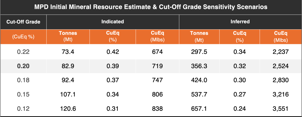
Examples of core from 2024 drilling at the Adit Zone: a) Axe-24-009: Diorite with chalcopyrite-pyrite in quartz-carbonate veining replacing feldspar, in 24 m high-grade interval assaying 1.00% Cu, 0.02 g/t Au and 6.72 g/t Ag from 218 to 242; b) Axe-24-011: Bands of massive pyrite-chalcopyrite in strong quartz-sericite-pyrite altered section of monzodiorite at 301 m, within broad 293 m interval assaying 0.23% Cu, 0.04 g/t Au and 1.71 g/t Ag from 102 to 395 m.
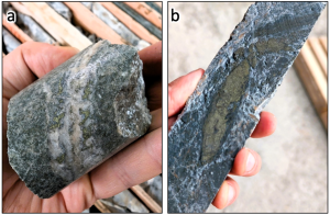
Examples of core from 2024 drilling at the Adit and South Zones: a) Axe-24-013 (Adit): Oxidized quartz gabbro with strong propylitic alteration and pyrite-chalcopyrite-epidote-malachite in veinlets at 80 m; b) Axe-24-015 (Adit): gabbro with propylitic alteration and veinlets/disseminated pyrite-chalcopyrite +/- bornite within 4 m high grade interval assaying 0.64% Cu, 0.14 g/t Au and 2.23 g/t Ag from 151 to 155; c) Axe-24-010 (South): Semi massive chalcopyrite-pyrite in quartz flooded porphyritic andesite breccia at 264 m
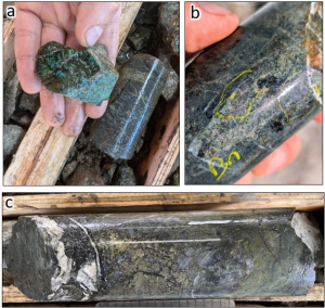
Examples of core from 2024 drilling at the Adit Zone, hole AXE-24-007: a) Strongly oxidized andesite breccia with pyrite-malachite in veinlets at 49 m; b) Hydrothermally altered diorite breccia with chalcopyrite-malachite-azurite-sphalerite in 13 m high-grade interval assaying 1.74% Cu, 0.03 g/t Au and 194.98 g/t Ag from 150.5 to 164 m; c) Massive chalcopyrite-pyrite in quartz flooded porphyritic dacite breccia at 222 m in 21 m interval assaying 1.24% Cu, 0.02 g/t Au and 5.36 g/t Ag from 206 to 227 m; d) Disseminated chalcopyrite-pyrite in diorite with late quartz stringers hosting chalcopyrite-molybdenum at 393 m in 51 m interval assaying 0.54% Cu, 0.01 g/t Au, 2.55 g/t Ag and 0.03% Mo from 347 to 398 m
Example of core from MPD-23-002 at 288 m with semi-massive chalcopyrite in 116 m interval assaying 0.34% Cu, 0.28 g/t Au and 1.71 g/t Ag from 199 to 315 m.
Example of core from MPD-23-001 at 511 m. Chalcopyrite and bornite within gypsum veins and potassic altered breccia in 75 m assaying 0.25% Cu, 0.23 g/t Au and 0.70 g/t Ag from 491 to 566 m.

Chairman Chris Taylor Presenting At A Vancouver Mineral Exploration Group Event

Ceo Claudia Tornquist Presenting At Munich Conference

Team Examining Core From Mpd

Field Crew Performing Exploration Work At Mpd
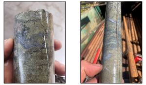
Examples of mineralized hydrothermal sulphide breccia from 2023 drilling at the West Zone. Left: AXE-23-011 at 878 m within 89-metre intercept reporting 0.32% Cu, 0.16 g/t Au and 0.95 g/t Ag from 873 to 962 m. Right: AXE-23-008 at 865 m within 153-metre intercept reporting 0.11% Cu, 0.17 g/t Au and 0.52 g/t Ag from 735 to 888 m.
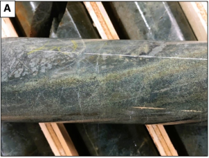
Examples of core from South Zone A) AXE-23-014: Fine disseminated pyrite-chalcopyrite-magnetite in brecciated intermediate volcanics and tuff beds at 740 m;
Examples of core from South Zone B) AXE-23-012: Pyrite-chalcopyrite in quartz and as patches in altered volcanics with garnet at 372 m.

West Zone AXE-23-001 – Altered andesite volcanoclastic breccia w/ quartz-chalcopyrite-pyrite disseminated and as patches in matrix

West Zone AXE-23-002 – Example a – Fragmental polymict breccia incl. chalcopyrite mineralized clasts in potassic altered rock flour matrix w/ disseminated to blebby chalcopyrite and pyrite

West Zone AXE-23-002 – Example b – Fragmental polymict breccia incl. chalcopyrite mineralized clasts in potassic altered rock flour matrix w/ disseminated to blebby chalcopyrite and pyrite

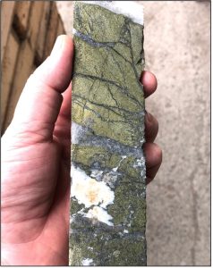
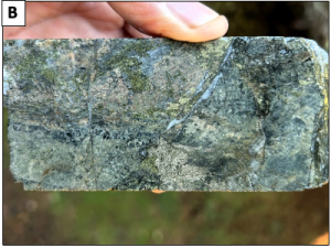
MPD-20-004 Core: Strongly Mineralized Quartz Veining with Chalcopyrite

MPD-20-004 Core: Strongly Altered Porphyry with Semi-Massive Sulphide Veining Dominated by Chalcopyrite

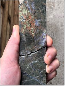
MPD-21-006 – Strongly Mineralized Hydrothermal Breccia with Chalcopyrite-Pyrite.

MPD-20-005 Core: Strongly Altered Porphyry with Sulphide Veining Dominated by Chalcopyrite

MPD-20-005 Core: Strongly Mineralized Quartz Veining with Chalcopyrite

MPD-21-009 – Bornite-Dominated Copper Mineralization as Disseminations and in Late Quartz Veining.

Drilling at MPD

Core logging at Kodiak’s facility in Merritt, BC

Team viewing core at Kodiak’s facility in Merritt, BC

Team at Kodiak’s facility in Merritt, BC

Drilling at Gate Zone, MPD

Malachite at MPD

Field crew in historical trench at Man Zone, MPD

Cu Oxide in historical trench at MPD

Field crew examining copper exposure at MPD

MPD Prospecting

Malachite at MPD

Kodiak team investigating copper oxide at MPD

Chairman Chris Taylor and team examine core at the MPD office in Merritt, BC
Dave Skelton, P.Geo., Vice President Exploration is the Qualified Person as defined by National Instrument 43-101, and has approved and verified the technical information produced by Kodiak in news releases and on this webpage. Historic data referenced herein is believed to be from reliable sources based on Kodiak’s review of available documentation and select verification work. However, the Company has not independently validated all historic work, and the reader is cautioned about its accuracy.